Latest
Following Highways England's rejection of the Councils' plans in December 2018, work continues to develop a broadly acceptable solution
(as reported by Chichester Post
here).
Hopefully this will complement CDC's Local Plan !
Back Story - how did we get here ?
Following cancellation of the Chichester A27 project in March 2017, Workshops involving interested parties from the Community were set up.
Their aim was to work towards a broadly acceptable solution and we attended these and worked with the Councils over the summer.
Highways England gave a September deadline for this to be achieved and despite the best efforts of our new MP were unwilling to extend that date.
Their offer was essentially Option 2 (see below) take it or leave it.
This being the case, it was agreed that the offer would not be taken up, because from a local point-of-view, Option 2 had some serious flaws. (See report in the Chichester Observer -
here)
West Sussex County Council produced an outline
consultancy brief
and appointed Consultants
Systra
to work on alternative plans with the intention to 'bid' for inclusion in Highways England's next Road Investment Strategy cycle (
RIS 2 )
Local involvement continues via. meetings with the the Build A Better A27 group (BABA27) on which we have a representative.
Systra were present at the BABA27 Meeting on 7th February and our report on this is
here
Systra then produced their "paper [which] introduces the approach to developing the `long-list' of suggestions to be taken forward to sifting in the next work package". This included some Northern Bypass options :-
-
- "New strategic northern route between A27 west of Fishbourne junction and near to Tangmere, with a junction at the A286 to give access to Midhurst and north Chichester, or no intermediate junction"
ie. One of the
'leaked' routes from 2015 (you'll need to scroll down the document to find northern options 4 and 5)
- "New local northern route between A27 west of Fishbourne junction and Temple Bar utilising and improving some existing local roads to limit new construction."
ie. Improving the current Rat Run.
- "New multi-purpose road northern route between A27 west of Fishbourne and near to the A27 at Portfield providing a stronger local functionality than route variants above, including junctions on B2178 and A286"
ie. The route considered and rejected in 1980, which one of our members has sketched out
here .
Our survey last year showed that more than 90% of our members were strongly (in some cases vehemently) opposed to a Northern route.
So, as the time scale for responses was short, we held an Extraordinary Committee Meeting on Wednesday 21st of March, which was attended by both committee and ordinary members. We worked through the 19 pages of Systra's
'Long List'
and resolved to oppose Northern options through the BABA27 process. Minutes of that meeting are
here
and our letter to WSCC setting out our position is
here
WSCC and CDC held meetings as follows during the first week of June 2018 to decide what to propose to Highways England.
WSCC
The Environment, Communities and Fire Select Committee meeting was held on Monday 4th of June.
It was expected that they would vote for the 'Mitigated Northern' option with 'Full Southern' as a reasonable alternative, as their
briefing paper recommended. It did however suggest that "this approach is unlikely to demonstrate to Highways England and
Government that there is community consensus". Perhaps influenced by this, a last minute motion saw the Southern option dropped and only the Northern proposed. Whether Highways England will see this as demonstrating consensus remains to be seen!
The Council's webcast of the meeting is
here.
CDC
A Special Cabinet Meeting held on Friday 8th of June 2018
Item. 5. A27 Chichester Bypass Improvements: Submission to the Government's Roads Improvement Strategy
" ... Approach A be supported as being desirable without indicating a preference for either option ie promoting both the 'mitigated northern route' and the 'full southern route'."
In the event, they decided to favour the 'Mitigated Northern' option with 'Full Southern' as a reasonable alternative.
Following the rejection of the Councils' A27 plans by Highways England in December 2018
and ahead of the proposed meeting between Highways England, the Councils and our MP, the
A27Action group
released a statement outlining their view of the way forward. We have a copy
here
Further details and links
Systra's final report
proposed two possible routes - one North and one South.
Their
Feedback Anaysis
suggested that local support is about evenly split between the two options ie. there was no consensus.
These are options 4 and 5 from 2015, which Systra refer to in their Final Report.
Our notes on the last BABA27 meeting (18th March) are
here
West Sussex County Council's
A27 Action Site
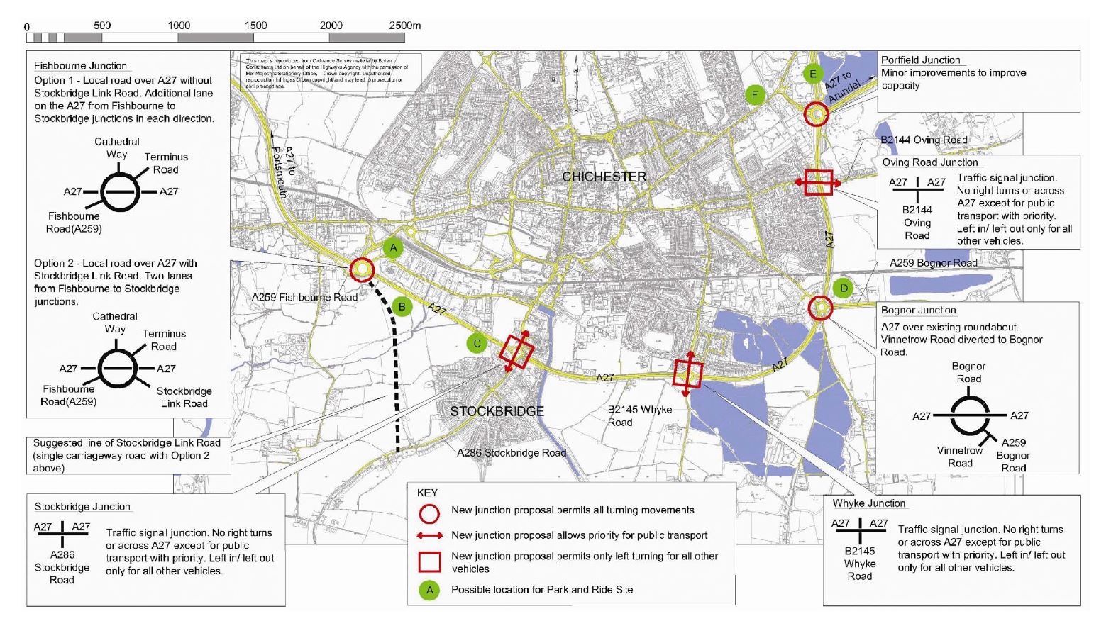
Visualisations of the different plans included in the 2016 consultation :-
-
- Option 1
- Option 1a
- Option 2
- Option 3
- Option 3a
The brochure with maps and details outlining the original plans is
here
Where the favoured Option 2 is not much different from the 2004 proposal documented
here
and which looked like
this
:-
As to the possibility of a Northern Bypass, we can't find documentation of the 1976 (?) proposal - please let the webmaster know if you find some!
While were waiting for Highways England to respond to the Council's proposals regarding the A27,
there was time for some homework
on how Green Bridges might be used in mitigation for routes North or South.
We visited the Green Bridge at Scotney Castle to see what it looks like and from the top you wouldn't know it was there (it's somewhere in the middle of this picture).
It has to be said though that if you stop the car and get out, it does nothing to mitigate the noise from the A21 below.
However, it is good for wildlife - no more squashed animals as they run the gauntlet of fast moving traffic - and for incorporating cycle paths etc.
So Green Bridges may help, but they are not Mitigation Magic.
There's lots more about them here :-
-
- Government Press Release on the Natural England Green Bridges Report
- Chartered Institute of Ecology and Environmental Management - Powerpoint
- Natural England Green Bridges Report
- Landscape Institute - Technical Guide
And finally, Highways England have published their proposed route for the
Stonehenge bypass.
"The 8 mile (13 kilometre) route, between Amesbury and Berwick Down in Wiltshire, [which] includes a 1.8-mile tunnel "
ie. a similar length to a northern bypass for Chichester and with a couple of miles of tunnel.
The planned cost is 1.6 Billion GBP.